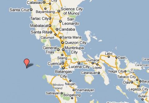
As of 1:29 this afternoon (Philippine Time), the Philippines was rocked by a 6.0 magnitude earthquake. The epicenter of the quake was traced on Lubang Island, Occidental Mindoro, (111 kilometers west of Mamburao, Occidental Mindoro at the South China Sea), with a depth of 72.4 kilometers and lasted for about 30 seconds. The quake is “tectonic” same type that shook Chile according to the Philippine Institute of Volcanology and Seismology (Phivolcs). Different areas where shook in different intensities, intensity V in Looc, Lubang Island in Occidental Mindoro; intensity IV in Quezon City, Mandaluyong, Makati, and Clark, Pampanga; and intensity II in Bagac, Bataan and Canlubang, Laguna. Here’s the full eart5hquake detail according to USGS. Magnitude 6.0 Date-Time Thursday, March 25, 2010 at 05:29:30 UTC Thursday, March 25, 2010 at 01:29:30 PM at epicenter Time of Earthquake in other Time Zones Location 13.748°N, 120.062°E Depth 64.3 km (40.0 miles) Region MINDORO, PHILIPPINES Distances 105 km (65 miles) W of Batangas, Luzon, Philippines 120 km (75 miles) SSW of Olongapo, Luzon, Philippines 125 km (80 miles) WNW of Calapan, Mindoro, Philippines 135 km (85 miles) SW of MANILA, Philippines Location Uncertainty horizontal +/- 4.7 km (2.9 miles); depth +/- 5.3 km (3.3 miles) Parameters NST=142, Nph=142, Dmin=423 km, Rmss=0.86 sec, Gp= 32°, M-type=teleseismic moment magnitude (Mw), Version=8 Source USGS NEIC (WDCS-D) Event ID us2010ugaf Philippines, Shook by 6.0 Magnitude Earthquake is a post from: Daily World Buzz

Read more here:
Philippines, Shook by 6.0 Magnitude Earthquake


